

Case study: Saudi Aramco’s in-house software uses 3D photographic data from unmanned aerial vehicles to explore hard-to-reach areas
| By Salem Shammari, senior geological consultant, surface geology division, Saudi Aramco |
The search for hydrocarbon deposits beneath the Earth’s surface can literally hit a wall during field trips to gather and interpret descriptive data that is then used to build quantitative, 3D models of the subsurface, or workflows for geological assessment. Rock outcrops could be treasure troves of information—until a high cliff or steep slope makes the site unreachable. The advent of unmanned aerial vehicles (UAVs) for exploration is changing all that.
The addition of remote sensing technologies to capture the required information allows drones to serve a dual function: not only do they overcome the safety hazards posed by high outcrops, but they contribute to an integrated workflow via a geographic information system that plans the drone’s flight. This new technology holds tremendous promise for continuing to change oil and gas exploration.
Saudi Aramco first tested UAVs for photogrammetry, or aerial surveying using a digital camera. The company hired a local vendor after securing necessary government approvals to test-trial, and despite some minor difficulties, the successful trial yielded knowledge on how to deal with the enormous data gathered, as well as how to process the photos for a digital elevation model.
A technology-driven company, Saudi Aramco has built its own software in-house. Called Geological Toolbox, it was enhanced specifically for outcrops. Users can enhance 3D models with many applications from this toolbox. For example, a virtual core can be made from the outcrop; then, the explorationist can compare it against his or her geological log sheet using the software.
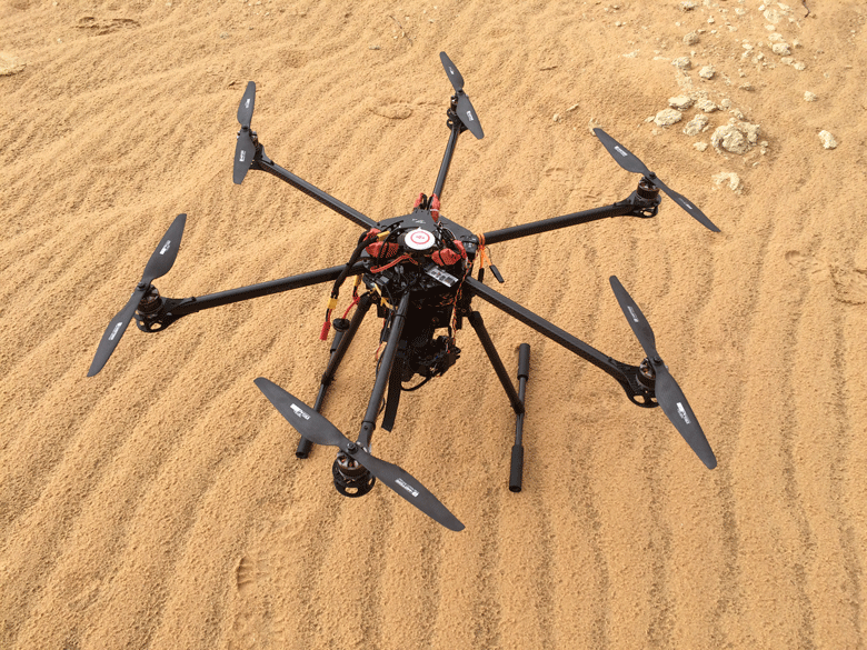
Unmanned aerial vehicles
Recently, Saudi Aramco’s EXPEC Advanced Research Centre (EXPEC ARC) Geology Technology/UAV Project managed a 3D capture of the western slope of an escarpment in central Arabia with an elevation of more than 150 metres, and many dangerous cliffs. The area is relatively large, with an approximately 6 kilometre top-down view of the terrain surrounding the escarpment (at 2 cm resolution) and a medium resolution (1.5 cm), oblique 3D photorealistic data capture of an entire length of the escarpment connecting various measured sections.
A high-resolution (sub-millimetre) 3D photorealistic data capture head-on to various measured section focus areas was an excellent result, with digital data and a 3D model depicted in the network.
 |
Overall, the benefits can be measured in efficiencies and enhanced safety. For instance, mapping and measuring a large outcrop that extends for kilometres requires many measured sections to understand the heterogeneity of the bed sets and lateral changes of the facies—and thus create a model of the depositional setting.
The process requires many teams, each with at least three people, in order to cover the area, with numerous field trips to the remote locality over many days.
With drone technology, a single team of four people can do the job in far less time and with no exposure to a potentially harsh environment. From the comfort of their offices, explorationists can check the data in a ‘virtual’ fly on their desktops, zoom in and out, follow each facies and make their own interpretations.
In this case alone, drones demonstrate a step-change in risk management, along with significant cost savings and greater efficiency.
Untapped potential
With the industry increasingly using UAVs for surveying and mapping, facility inspection and surveillance, refinements will add to their value. As with any type of aircraft, factors such as heat, precipitation and turbulence can diminish performance. Consistent performance in all types of weather would be an improvement.
 Saudi Aramco’s drone wish-list includes the capability to conduct a “virtual geological field scout” and more accurately document different geological features and trace each facies laterally—which would prove a boon to geoscientists.
Also missing in drone-related field work is the ability to obtain a rock sample (or hand specimen) from high cliffs for further geological analysis—for example to check the texture of grains and clay types, or analyse rock porosity and permeability.
Longer battery life and greater payload of the unmanned aerial vehicles, as well as enhancements in data collection are also eagerly awaited.
 This article is extracted from a report produced by MEED and Mashreq titled Disrupting Oil & Gas. Click here to download the report
To know more about the MEED Mashreq Partnership, get in touch with us at MEEDMashreqPartnership@meed.com or find more info on www.meedmashreqconstructionhub.com
You might also like...


Arada awards $167m Masaar construction contracts
16 April 2024


A MEED Subscription...
Subscribe or upgrade your current MEED.com package to support your strategic planning with the MENA region’s best source of business information. Proceed to our online shop below to find out more about the features in each package.